


Research conducted by researchers at the Graduate Program in Remote Sensing (PPGSR) and the State Research Center for Remote Sensing and Meteorology (CEPSRM) reveals that the recent soil and rock movements in the state of Rio Grande do Sul represent the largest event ever recorded in Brazil. Covering 40% of the state’s total area, equivalent to 12,000 square kilometers in the Caí, Sinos, Pardo, Alto Jacuí, Vacacaí-Mirim and Taquari-Antas basins, more than 5,000 landslide scars have already been identified. However, the researchers estimate that this number could exceed 12,000 points by the end of the project.
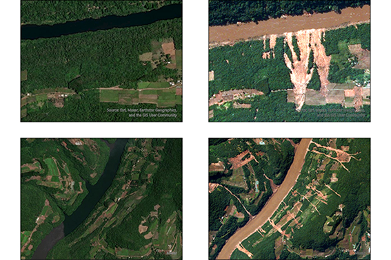
The data obtained so far is being integrated into the WebMap of Mass Movements for support teams in the disaster situation-RS – May 2024, an online tool that allows you to visualize, measure and obtain geographical coordinates of the mass movement scars mapped by the team. The WebMap, part of the UFRGS Geographic Information Repository for Decision Support – Rio Grande do Sul 2024, also includes detailed information such as images, hydrography, geology, flood spots, contour lines and points mapped by NASA.
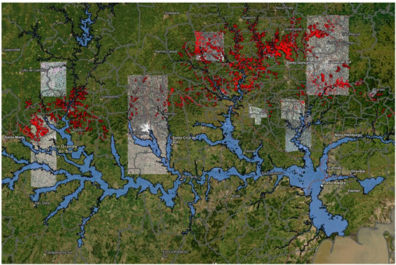
The relevance of these studies for decision-making by municipalities and communities is highlighted and has been widely publicized by the main media outlets in the state. For more information on the study and its repercussions, follow the links below:
- GZH: 5,000 scars: mapping shows that RS recorded the largest event of soil and rock movements in Brazil
- CORREIO DO POVO: Rains in RS caused the largest event of soil and rock movements on hillsides ever to occur in Brazil, says UFRGS
- UFRGS: UFRGS maps mass movement resulting from recent rains
In addition to the mapping carried out, field teams are conducting weekly work to advise municipalities and communities about risk areas, especially those where soil and rock instabilities are not easily identified by satellite images.